Little Fire explodes to 700 acres in the hills south of Pleasanton, forcing Ruby Hill and Sunol-area evacuations
A fast-moving grass fire ignited Tuesday afternoon near Sunol and burned roughly 700 acres in about two hours, putting the Ruby Hill community and homes along Vineyard Avenue under mandatory evacuation as crews battle heat, wind and steep terrain.

By David Weaver
Publisher & Editor
Published July 21, 2026, 8:05 PM ET
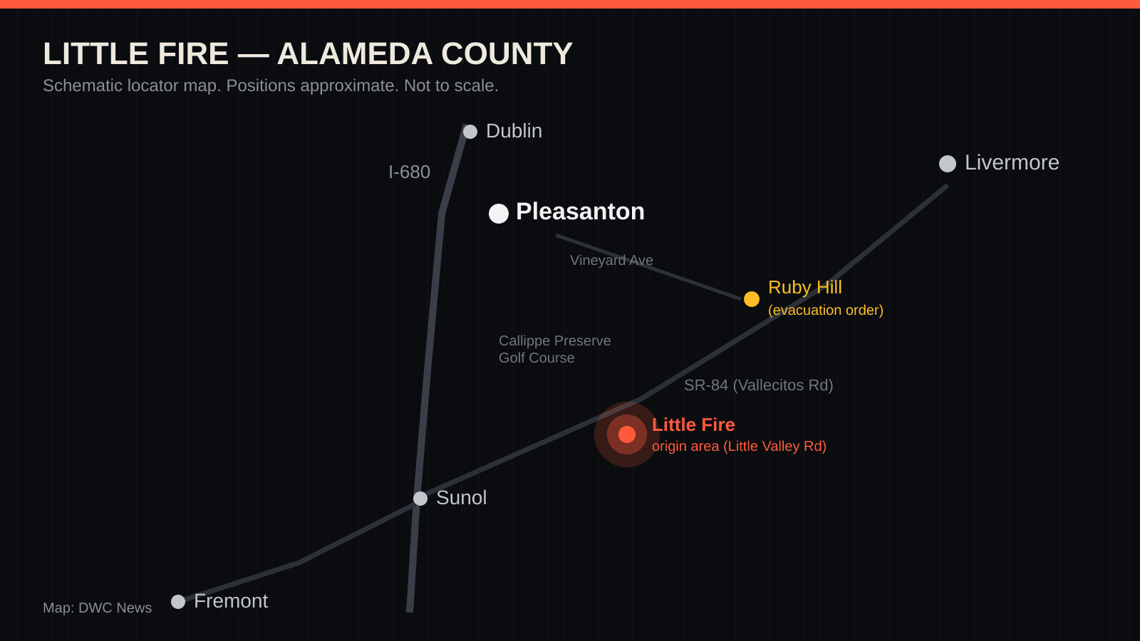
A grass fire that ignited Tuesday afternoon in the golden hills between Sunol and Pleasanton grew with startling speed — from a fresh smoke column to roughly 700 acres in about two hours — and by early evening had pushed mandatory evacuation orders into one of the East Bay's most exclusive neighborhoods. CAL FIRE is calling it the Little Fire, after Little Valley Road near where it began. As of 4:50 p.m. Pacific time, containment stood at zero.
What happened, hour by hour
The first reports came in Tuesday afternoon from the area of Little Valley Road and Hubbard Lane, in unincorporated Alameda County south of Pleasanton — just southeast of the city-owned Callippe Preserve Golf Course and, according to CBS News Bay Area, west of the decommissioned Vallecitos Nuclear Center on the SR-84 corridor.
The growth curve tells the story of the afternoon. By about 3:05 p.m. the fire had covered some 50 acres, per Pleasanton Patch. By 3:30 p.m. it was roughly 150. By 4:35 p.m., ABC7 and CAL FIRE's incident reporting put it between 400 and 700 acres — and by 4:50 p.m., multiple outlets settled on approximately 700 acres, still with no containment line around any of it. That is a grass fire covering more than a football field a minute at its fastest, which is exactly how fires behave in cured summer grass on steep ground during a heat advisory.
KTVU, citing Battalion Chief Raul Medina, reported that crews were hampered by steep terrain and unpaved roads but that air tankers were slowing the fire's spread, with CAL FIRE, the Alameda County Fire Department and Livermore-Pleasanton Fire all committed to the incident.
Who has been told to leave
Alameda County issued Level 3 evacuation orders — leave immediately — for four zones: ALC-072 in the unincorporated Sunol area, and PLS-080, PLS-081 and PLS-103 on Pleasanton's southeastern flank. Per Pleasanton Patch, the orders reach east of the golf course and west of Isabel Avenue, which takes in the gated Ruby Hill community and the homes along the Vineyard Avenue corridor that runs between Pleasanton and the Livermore Valley wine country.
Residents can confirm their own zone status at community.zonehaven.com, and should treat official Alameda County Sheriff and CAL FIRE alerts — not news coverage, ours included — as the authority on when it is safe to return.
Track What Happens Next
Little Fire tracker: what's confirmed, what isn't, and what to watch
The current state of the Little Fire south of Pleasanton: verified facts with sources, claims we could not yet confirm, and the concrete next developments to watch for.
⚠ The data behind this tool was last verified July 20, 2026 and may be out of date. Treat results as historical context, not current figures.
Do not make evacuation decisions from this page. If you are in the area, follow official alerts from the Alameda County Sheriff's Office and CAL FIRE, check your zone at community.zonehaven.com, and leave immediately if your zone is under an order.
Status: About 700 acres with 0% containment as of 4:50 p.m. PT Tuesday, July 21 — evacuation orders active for Ruby Hill and the Sunol area.
Confirmed
- ✓ The fire broke out Tuesday afternoon near Little Valley Road and Hubbard Lane in the unincorporated Sunol area, southeast of Callippe Preserve Golf Course (CAL FIRE; multiple Bay Area outlets).
- ✓ It grew from roughly 50 acres shortly after 3 p.m. to about 700 acres by 4:50 p.m. with zero containment (ABC7; CBS News Bay Area).
- ✓ Level 3 evacuation ORDERS — leave immediately — cover zones ALC-072, PLS-080, PLS-081 and PLS-103, including the Ruby Hill community and homes along Vineyard Avenue (CAL FIRE; Patch).
- ✓ CAL FIRE, Alameda County Fire and Livermore-Pleasanton Fire are on the fire, with air tankers slowing its spread over steep terrain (KTVU, citing Battalion Chief Raul Medina).
- ✓ A National Weather Service Heat Advisory was in effect Tuesday: high near 97°F with west winds gusting to about 18 mph (NWS).
- ✓ No structures had been reported damaged or destroyed as of Tuesday evening (CBS News Bay Area; KTVU).
Not yet verified
- ? Cause — no official determination has been released.
- ? Exact ignition time — initial reports cluster around 2:40 p.m., while at least one account cites 3:39 p.m.; CAL FIRE's final log should settle it.
- ? Any count of structures threatened — no official figure had been published as of our last check.
Watch next
- CAL FIRE's next incident update — fresh acreage and a first containment numberupdates typically post morning and evening
- Whether evacuation orders expand, downgrade to warnings, or liftvia Alameda County alerts / Zonehaven
- Overnight humidity recovery and calmer winds, which usually slow Bay Area grass firesovernight into Wednesday
- An official cause determinationdays to weeks
How this is calculated
Confirmed items carry a primary source (CAL FIRE's incident page, National Weather Service products) or multiple independent Bay Area outlets reporting the same fact. Unverified items are claims from a single account or points where reports conflict. The watch list holds concrete expected events, not speculation. Every line is re-reviewed at each story update, and the verification time is shown below.
Data as of July 20, 2026 · verified July 20, 2026 · v1
Assumptions, limitations & sources
Assumptions
- · Official acreage and containment figures lag the fire's real behavior by minutes to hours.
Limitations
- · This tracker reflects the last verified report shown below — an active fire changes faster than any news page.
- · Evacuation zone boundaries are defined by Alameda County's alert system, not by this page.
Sources
- CAL FIRE — Little Fire incident page — California Department of Forestry and Fire Protection, checked July 20, 2026
- CBS News Bay Area — Little Fire coverage — CBS News Bay Area, checked July 20, 2026
- ABC7 News — live Little Fire coverage — ABC7 San Francisco, checked July 20, 2026
- Pleasanton Patch — evacuation orders — Patch Media, checked July 20, 2026
- NWS forecast — Livermore-Pleasanton area — National Weather Service, checked July 20, 2026
This is what modern SEO looks like: not just an article, but a useful resource people can return to, cite, and share. See how this newsroom is growing · See DavidWeaver's SEO packages
Damage so far
Here is the honest answer as of Tuesday evening: no structures had been reported damaged or destroyed, and initial coverage reported no injuries. The fire has so far burned grass and oak-studded rangeland rather than neighborhoods — the reason the evacuation math matters is that Ruby Hill's roughly 850 homes and the Vineyard Avenue corridor sit directly in the direction the fire and the wind were moving when orders were expanded. Those numbers can change quickly; our tracker above will carry any confirmed damage reports as they are verified.
Where this is happening
For readers outside the Bay Area: the fire sits in the Tri-Valley's southern hills, a triangle of grassland framed by real communities on every side —
- Sunol — the unincorporated town of fewer than a thousand people nearest the ignition point, tucked along I-680 and Niles Canyon.
- Pleasanton — a city of about 80,000 immediately north; its Ruby Hill and Vineyard Avenue areas are under evacuation orders.
- Livermore — the Tri-Valley's largest city and its wine country lie just east of the evacuation zones, across Isabel Avenue.
- Dublin — north of Pleasanton along I-680.
- Fremont — southwest, connected to Sunol by Niles Canyon Road (SR-84).
The I-680 corridor threads directly through this landscape, and SR-84 — Vallecitos Road — runs northeast from Sunol toward Livermore, passing close to the fire area.
The weather behind the fire
Tuesday was primed for exactly this. The National Weather Service had a Heat Advisory in effect for the interior East Bay from mid-morning until 9 p.m., with Livermore-Pleasanton forecast to reach about 97°F under sunny skies and a west wind around 8 mph gusting to roughly 18 mph. That combination — triple-digit-adjacent heat, single-digit humidity typical of advisory afternoons, and a persistent westerly push — dries fine fuels to tinder and carries flame east and upslope. It is consistent with what happened: the evacuation zones expanded north and east, toward Ruby Hill and Isabel Avenue, downwind of the origin.
The one favorable card is the Bay Area's usual overnight pattern: marine air, rising humidity and calmer winds after dark tend to take the run out of grass fires and give crews their best hours. Whether that holds tonight is the next thing to watch.
These hills have burned before
The Little Fire is burning through one of the most fire-experienced corners of the Bay Area.
In August 2020, the SCU Lightning Complex — ignited by a freak dry lightning siege — burned nearly 396,000 acres across six counties, destroyed 222 structures, and stands among the largest wildfires in California's recorded history. Its Calaveras Zone ignited in these same uplands, near the Sunol Regional Wilderness and Calaveras Reservoir, just south of today's fire. The same 2020 lightning outbreak also produced the Creek Fire near Welch Creek and Calaveras roads in Sunol, which burned 744 acres.
More recently, a June 2022 vegetation fire in the hills west of Pleasanton near I-680 — the Canyon Fire — forced brief evacuations and injured two firefighters, one struck by a falling tree after a water drop and another suffering heat exhaustion; both were expected to recover. And Alameda County carries the deepest scar in Bay Area fire memory: the 1991 Oakland Hills firestorm, among the most destructive in American history.
The pattern is consistent: these east-of-680 grasslands cure by mid-summer, and when heat, wind and an ignition line up, they run. Tuesday they lined up.
What we don't know yet
No cause has been announced, and one detail in the early reporting conflicts: initial dispatch accounts put the start around 2:40 p.m., while at least one outlet cites 3:39 p.m. CAL FIRE's finalized incident log should resolve the timeline. We are treating both the cause and the exact ignition time as unconfirmed, and the tracker above separates every such item from what is verified.
What happens next
Watch for CAL FIRE's next incident update — the first containment percentage is the number that signals crews are getting a line around this. Watch whether the evacuation orders expand further toward Isabel Avenue or begin downgrading to warnings. And watch the overnight weather: if the marine influence arrives on schedule, Wednesday morning's report should look meaningfully better than Tuesday evening's.
This story will be updated as official information is verified. If you are in an affected zone, follow Alameda County Sheriff and CAL FIRE alerts and leave immediately if ordered.
Sources
- CAL FIRE incident page — Little Fire — California Department of Forestry and Fire Protection · primary source
- ABC7 News live coverage of the Little Fire — ABC7 San Francisco
- Evacuation orders issued as 'Little Fire' grows — Pleasanton Patch
- Sunol vegetation fire triggers evacuations — KTVU FOX 2
- Fast-growing wildfire prompts evacuation order in Ruby Hill — Pleasanton Weekly
- Little Fire burning south of Pleasanton in Sunol spreads; evacuations expanded — CBS News Bay Area
- 400-acre wildfire south of Pleasanton prompts evacuation orders — NBC Bay Area
- NWS forecast for the Livermore-Pleasanton area (Heat Advisory) — National Weather Service